McGraths Hill Effluent Reuse and Wetlands Project
In 1995, Council took steps to develop 76 ha of land (which is predominantly floodplain land), under the guidance of a Steering committee, as an integrated reuse and wetland system.
1. Why is the scheme needed?
The McGraths Hill Sewage Treatment Plant (STP), which was originally constructed in 1938 and then upgraded in 1969 to serve an equivalent population of 9,500. The plant was designed to carry out tertiary treatment of the effluent including disinfection and oxygenation in a series of four polishing ponds which had a total detention time of approximately 25 days.
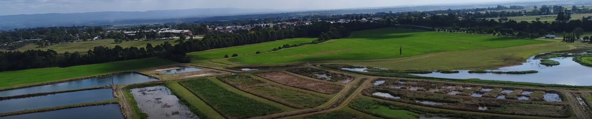
For a number of years effluent from the polishing ponds was discharged to South Creek. For the last 15 years or so, the discharge has been directed via a natural depression in the landscape which is reported to have originally contained an ephemeral wetland. With the addition of effluent flow, the wetland has become a perennial water body covering approximately 5 hectares (ha) of open water and 3 ha of marshland. In 1988 Council gained approval from the EPA to implement a project to increase disinfection detention time to 30 days and reuse effluent on approximately 20 ha of cropping land and 6 ha of woodlot adjacent to the STP. The plant is currently licensed by the EPA for discharge to South Creek and irrigation on site.
In 1995 Council took steps to acquire an additional 50 ha of predominantly floodplain land approximately bounded by the STP land, South Creek and Windsor Road. A Steering Committee was established comprising representatives from Council, Hawkesbury Nepean Catchment Management Trust, EPA, Greening Australia, University of Western Sydney and Department of Land & Water Conservation, to determine a concept to develop the combined 76 ha of land as an integrated reuse and wetland system with the objectives of:
- Minimising effluent discharged to South Creek and optimise reuse whilst meeting EPA requirements.
- Improve the visual amenity of the entrance to Windsor through enhancement of the natural environment.
- Provide an economic return whilst minimising management costs.
- Provide and improve floodplain wetlands, South Creek riparian zone and other potential habitats.
- Provide a passive recreation resource; and maximise educational and research opportunities.
2. What does the scheme involve?
Council engaged Lyall & Macoun Consulting Engineers on behalf of a Consortium of specialised consultants including; Woodlots & Wetlands, Pittendrigh, Shinkfield & Bruce, Molino Stewart Environmental Services and Sainty & Associates Pty Ltd, to prepare concept plans for the development of the site. ln carrying out this work an extensive community consultation program has been undertaken which has provided many useful suggestions for the way the site should be developed as well as providing a forum for the expression of community concerns about the project.
The layout of the proposed scheme, involves the following key features:
- Retention of the existing STP and disinfection ponds together with modified operation of the existing woodlot and agricultural irrigation area.
- Maximum use of effluent on the site consistent with soils and landscape constraints. Although there is insufficient land available to totally reuse all the available effluent, it is anticipated 80% will be reused on the site.
- Retention and enhancement of the existing open water wetland located immediately south of Windsor Road. The water level in this wetland will be allowed to increase by 800 mm in winter which will provide effluent storage for use in the summer months and as the level recedes, will help provide open mudflat habitat favoured by migratory wading birds.
- Construction of approximately 6 ha of bays to be planted with wetland plant species. This wetland area will be primarily used for the further reduction of phosphorous and nitrogen in the effluent before it is reused for irrigation of woodlots and landscaping, or excess allowed to discharge to South Creek.
- Water levels in these bays will be allowed to increase by up to 500 mm in winter to provide storage of effluent for use in the summer months. The provision of about 100 ML of storage in the existing and constructed wetlands will enable the full irrigation demand of the irrigation areas to be met over summer.
- Expansion of the area used for agriculture from 20 to 31 ha. This area will primarily be used for growing lucerne and other fodder crops. The area will be irrigated with effluent taken from the last of the disinfection ponds, which has nitrogen and phosphorus concentrations suitable for sustainable irrigation onto lucerne.
- Expansion of the woodlot area from 6 ha to 17 ha. This area will be planted with high water use tree species which will be irrigated with effluent taken from near the outlet to South Creek. This effluent will have low nutrient levels which can be safely irrigated onto woodlots which, as they mature, have low nutrient requirements.
- Construction of a dosing plant to chemically treat a portion of the effluent to reduce phosphorus levels to less than 1 mg/L. This treatment will be carried out on all water discharged into the constructed wetlands and which will either be used to irrigate the woodlots and landscaping, or will eventually be released to South Creek. In an average year approximately 430 ML or 54% of the total effluent will be treated in this system.
- Reduction in the operating level of the existing disinfection ponds by about 500 mm in order to provide wet weather and operational storage of at least 10 days, whilst maintaining disinfection levels to those required for irrigation of fodder crops. Use of this storage and the storage capacity of the wetlands will allow releases to South Creek to be made at times when maximum environmental advantage can be gained.
- Planting of 5.2 ha of landscaping to enhance the visual, recreation and habitat values of the area. These plantings will be selected largely from trees and shrubs once endemic to the area. The landscape areas will be irrigated with the same treated effluent as the woodlots, applied at a lower rate, consistent with their water and nutrient requirements.
- Construction of a network of paths, boardwalks, bridges and bird hides to allow public access to the area for walking and bird watching. Explanatory signposting will be provided and there will be facilities for educational activities and research.
3. What will the scheme do?
The McGraths Hill STP treats an average annual flow of about 800 ML of sewerage.
It is estimated that prior to 1988, evaporation from the disinfection ponds and wetland area would have reduced the discharge to South Creek to about 715 ML/year.
With the implementation of some effluent reuse for cropping in 1988, the residual flow to South Creek was reduced to about 520 ML/year and the nitrogen and phosphorus loads were reduced by approximately 25%.
With the implementation of the proposed scheme it is anticipated that the residual effluent discharged to South Creek will be reduced to approximately 200 ML/year. More importantly, the increased treatment of effluent prior to discharge is expected to reduce the nitrogen level to less than 5.0 mg/L and the phosphorus level to less than 2.0 mg/L.
The residual pollutant loads which will occur after implementation of the scheme represent a reduction of 99% compared to conditions prior to 1988. The project will thus contribute substantially towards improving the water quality in South Creek and the Hawkesbury River.
4. Construction and operation
Soils and geotechnical surveys of the site have demonstrated that the site is suitable for the proposed irrigation. The constraints identified were some localised salinity, acidity that would need lime correction and a very low infiltration rate in reformed soils. Perennial vegetation such as lucerne was recommended as a method of maintaining good soil drainage. The wetland sub-soil had been compacted during construction to minimise percolation. A modular wetland design will minimise short circuiting.
A comprehensive monitoring and management plan is proposed. Parameters to be monitored include flow, (Nitrogen, Phosphorus, Biochemical Oxygen Demand, pH etc), Soils and Sediments, Bacteria count, algae blooms and mosquito population.
The project involves substantial earthworks to create the constructed wetlands and the facilities for further treatment of the effluent prior to discharge into the constructed wetland. In addition, the project also involves engineering works for the installation of the irrigation system and extensive plantings for the wetland, woodlots and landscaped areas. The estimated capital cost to implement the proposed scheme is $2.2 million. This cost includes the establishment of the constructed wetland, clearing and planting of woodlots, establishment of lucerne pastures and extensive landscaping particularly along Windsor Road and the banks of South Creek.
5. Summary
The proposed scheme meets the multiple objectives set by Council and the community while providing a sustainable effluent reuse scheme. A key outcome from the project will be that nutrient discharge to South Creek will be reduced to negligible quantities. In addition, the aesthetic, recreational and habitat values of the site, including the existing wetland, will be substantially enhanced.
Page ID: 162713
